Easy to Use Application Provides Highly Effective Visual Representations of Site Security Options

Vumii Imaging, Inc., a developer and manufacturer of thermal and near-infrared illumination cameras, is designed to help security integrators and consultants, as well as architecture and engineering firms, efficiently design site security plans.
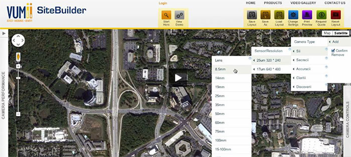
Vumii SiteBuilder, a web application based on Google Maps’ API, allows users to assess a site and build a surveillance strategy based on the specific needs of a facility and its surroundings.
Specifically, the application enables users to place virtual cameras within a graphical representation of the land that a facility encompasses, providing an accurate understanding of a camera’s field of view and range. This approach demonstrates what the user will see, including potential gaps in surveillance coverage and how different camera, sensor and lens combinations affect the field of view.
Through help icons, videos, and text, Vumii SiteBuilder enables users to see the advantages of near-IR and thermal IR technology and their different uses. It also provides an understanding of the military standard, Johnson’s Criteria. Users can also emulate, at different ranges, the types of targets they will want to view through the system including people, land-based vehicles and boats.
The solution allows users to control a wide variety of camera specifications including camera type (fixed or pan/tilt), sensor type (near-IR CCD or thermal engine), sensor resolution, lens size and mounting height. Additionally, users can build, save and recall an unlimited number of site layouts.
“Vumii SiteBuilder is a highly-effective tool for giving users an understanding of specific site security requirements,” said Chris Ruttle, CEO, Vumii Imaging. “We designed it to be an extremely easy-to-use, visual, communication tool that does not require prior industry training, making it ideal for consultants and integrators to quickly build and communicate security plans to their customers.”